Economic Report on Scottish Agriculture 2011 Edition
Invalid description field:Agriculture
This document is part of a collection
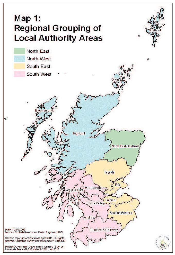
Information by geographical area (Map 1)
Findings in this publication from the June Agricultural Census are presented by region and "regional grouping". Each agricultural holding is allocated to one of the 891 parishes in Scotland. These parishes can then be aggregated up to the higher geographies like local authority ( LA), regional grouping (groupings of LAs) and region. The table below presents which local authorities lie within each regional grouping and region.
Most parishes lie wholly within a single LA area and therefore it is easy to allocate these areas to higher geographies. However, it is important to note that not all parishes lie wholly within a single LA boundary. In these cases, where the parish straddles LA boundaries, the LA in which the majority of the parish's area is located is assigned the whole parish.
Regions, regional groupings and Local Authority areas
Region |
Regional Grouping |
Local Authority |
|---|---|---|
North West |
Shetland |
Shetland |
Orkney |
Orkney |
|
Eileanan an Iar |
Eileanan an Iar |
|
Highland |
Highland |
|
North East |
NE Scotland |
Aberdeen City |
Aberdeenshire |
||
Moray |
||
South East |
Tayside |
Angus |
Dundee City |
||
Perth & Kinross |
||
Fife |
Fife |
|
Lothian |
East Lothian |
|
City of Edinburgh |
||
Midlothian |
||
West Lothian |
||
Scottish Borders |
Scottish Borders |
|
South West |
East Central |
Clackmannan |
Falkirk |
||
Stirling |
||
Argyll & Bute |
Argyll & Bute |
|
Clyde Valley |
East Dunbartonshire |
|
East Renfrewshire |
||
City of Glasgow |
||
Inverclyde |
||
North Lanarkshire |
||
Renfrewshire |
||
South Lanarkshire |
||
West Dunbartonshire |
||
Ayrshire |
East Ayrshire |
|
North Ayrshire |
||
South Ayrshire |
||
Dumfries & Galloway |
Dumfries & Galloway |
There is a problem
Thanks for your feedback